Have questions about your land or property? We're here to guide you every step of the way.

Topographic surveying involves the measurement and mapping of the natural and man-made features of a land surface. This includes elevations, contours, trees, buildings, fences, and other visible features. It plays a critical role in planning construction, landscaping, roadworks, and infrastructure projects. Engineers and architects rely on topographic maps to understand the lay of the land before initiating design and development processes.

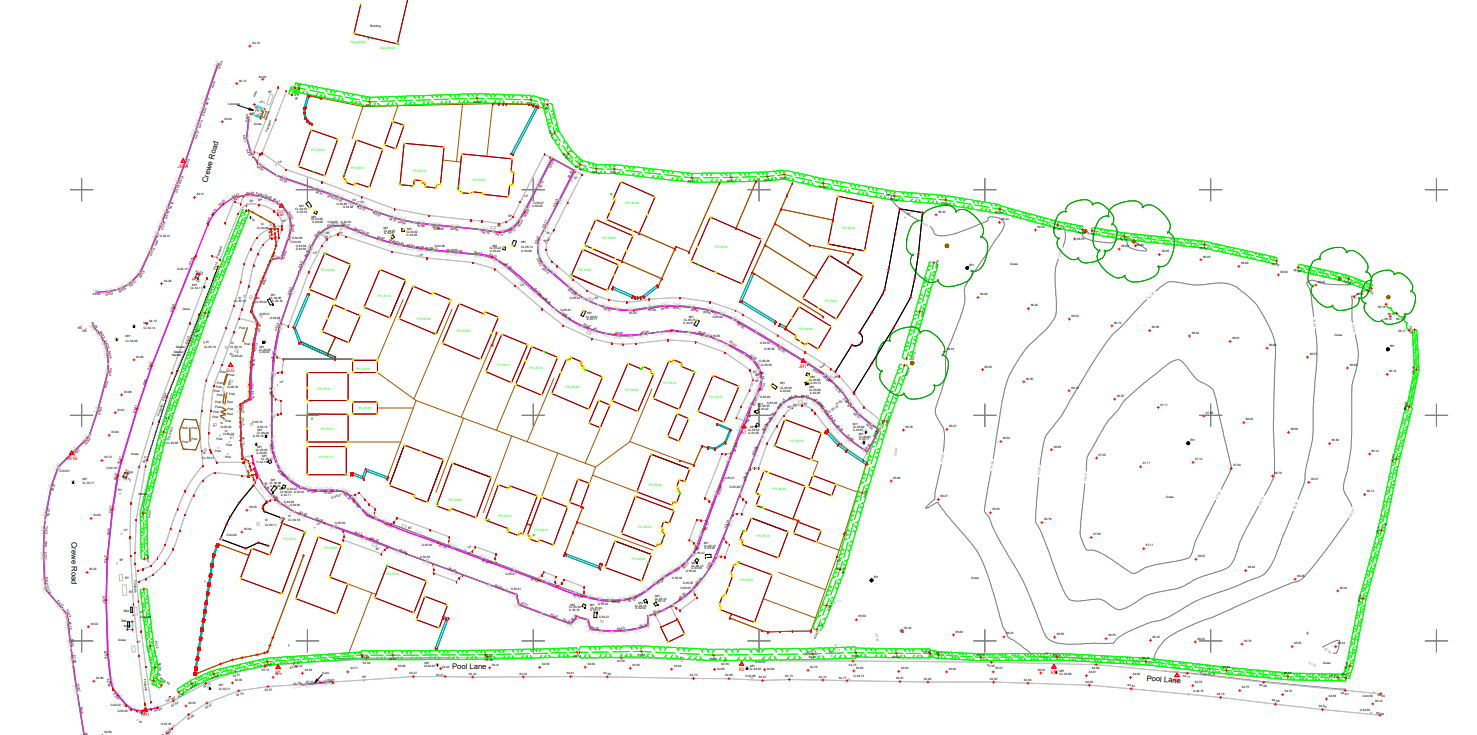
Boundary or title surveys are conducted to determine the exact property lines and corners of a parcel of land. These surveys are often required for property transactions, resolving disputes, or securing building permits. The surveyor researches historical records, plats, and deeds, and physically marks the boundaries to ensure clarity and avoid encroachments or legal issues.

Construction staking, also known as site layout survey, involves placing markers on the ground to guide the construction of buildings, roads, pipelines, and other structures. It ensures that every element of a project is built in the right place, at the correct elevation, and according to design specifications. This is a crucial step in translating plans into physical form with precision.

Subdivision surveys are used to divide a tract of land into smaller lots or plots, often for the purpose of development or sale. These surveys require careful compliance with local zoning laws, planning guidelines, and government regulations. Surveyors prepare detailed maps showing each new lot, street, utility access point, and easement to assist developers and local authorities.
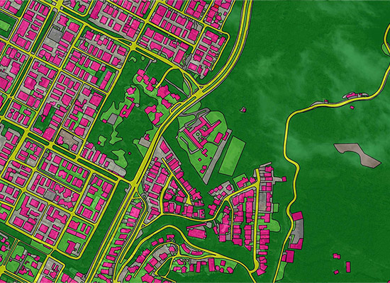
Geographic Information Systems (GIS) and mapping services combine spatial data collection with digital technologies to produce layered maps and spatial databases. These services are used in urban planning, environmental studies, utilities management, and disaster planning. By integrating satellite imagery, drone data, and GPS, surveyors can deliver highly accurate geospatial information for large-scale projects.

Beyond measurements, modern surveyors offer consultancy services to landowners, developers, and government agencies. This includes analyzing terrain, advising on regulatory compliance, planning optimal use of land, and providing risk assessments. With deep knowledge of land laws, zoning codes, and environmental considerations, surveyors guide projects from concept to completion with technical and legal clarity.

Comprehensive mapping of property features using state-of-the-art instruments to capture precise three-dimensional data. Detailed elevation data (contours, spot heights, elevation models). Mapping of existing features: buildings, roads, utilities (visible), vegetation, water bodies, etc. Accurate terrain representation for planning and design. Data delivered in various formats (e.g., CAD, GIS, point clouds). Suitable for: architectural design, infrastructure projects, land development, environmental studies.

Precise determination and marking of property boundaries according to official records and legal documents, employing high-accuracy positioning technology. Verification and establishment of property corners and lines. Preparation of detailed boundary plans and legal descriptions. Resolution of boundary disputes. Subdivision and consolidation surveys. Integration with land records and cadastral databases. Compliance with local land survey regulations in Kerala. Highlight your expertise in local regulations and accurate documentation.
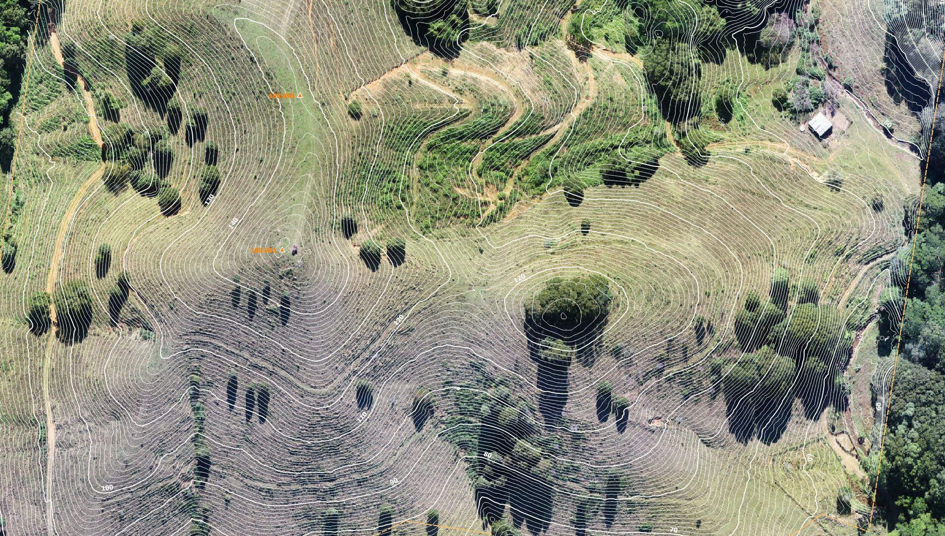
Creation of accurate contour lines representing land elevation, derived from detailed elevation data. Generation of contour maps with customizable intervals. Clear visualization of terrain slope and topography. Essential for site planning, earthwork calculations, drainage design, and flood analysis. Integration with CAD and GIS software. Emphasize the clarity and precision of your contour representations.
Surveys conducted post-construction to document the precise location and dimensions of completed structures and utilities, ensuring accurate record-keeping. Accurate measurement of built elements. Verification of construction compliance with design plans. Creation of detailed as-built drawings and models. Essential for facility management, maintenance, and future modifications. Highlight the accuracy and accessibility of your as-built documentation.

Precise marking of proposed structures and design elements on the ground using advanced surveying instruments based on design plans. Accurate transfer of design coordinates to the field. Setting out of building lines, foundations, roads, pipelines, etc. Real-time guidance for construction teams. Improved accuracy and reduced errors in construction. Emphasize the precision and efficiency of your layout services.

Accurate measurement of material volumes using advanced terrain modeling and data acquisition techniques (e.g., drone surveys, terrestrial scanning). Precise calculation of cut and fill volumes. Monitoring of material quantities for inventory management. Cost estimation for earthwork projects. Data delivered in detailed reports and models. Highlight the accuracy and efficiency of your volume calculation methods.

Creation of accurate representations of the ground surface using collected elevation data. Generation of triangulated irregular networks (TINs) and gridded elevation models. Foundation for various analyses, including contour generation, slope analysis, and drainage modeling. Data compatible with GIS and CAD software. Explain the benefits of using these models for analysis and visualization.

Utilizing Global Navigation Satellite Systems (GNSS) for precise positioning and data collection. Establishment of control points and survey networks. Real-time kinematic (RTK) and post-processing techniques for high accuracy. Suitable for large-area surveys and remote locations. Integration with other surveying methods. Highlight the accuracy and efficiency of your GNSS technology.

Acquiring high-resolution aerial imagery using Unmanned Aerial Vehicles (UAVs) and processing it to create detailed maps, 3D models, and orthophotos. Rapid data acquisition over large areas. Generation of high-resolution Orth mosaic imagery. Creation of detailed 3D point clouds and textured models. Applications in topographic mapping, site monitoring, infrastructure inspection, and environmental assessment. Showcase the speed, cost-effectiveness, and detailed output of your aerial mapping capabilities.
Converting survey data between different formats and integrating it with other spatial information systems (e.g., GIS). CAD to GIS conversion. Data cleaning and processing. Georeferencing and data rectification. Customized data delivery formats. Emphasize your ability to provide data in client-preferred formats for seamless integration.